

Sharma and Bharti [as civil engineers reporting on geological subjects?] reported in early 2025 that the rising global energy demand has driven researchers to locate new uranium deposits, with sandstone types contributing nearly 40 per cent of uranium production. The present review provides a comprehensive understanding of the genesis and classification and mentions some global examples of sandstone-type uranium deposits, the focus being on the geological settings of each type.
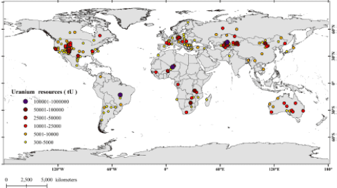 Global U-abundance map of sandstone-type deposits. Data source: World
Distribution of Uranium Provinces,\IAEA (2021).
Understanding these factors helps locate similar deposits, especially in North-East India, where research is limited. There, uranium enrichment is controlled by numerous factors such as source rocks, sedimentary structures, permeability barriers, reductants and cap rocks. The present study underscores the need for integrated methods for exploration of sandstone-type deposits where remote sensing can be combined with geophysical and geochemical techniques.
Identifying such deposits requires understanding geological formations, in-situ structural observations, lithology, stratigraphy, palaeoclimate, source and host rocks, transport mechanisms, depositional conditions and reductants. Uranium exhibits high geochemical mobility due to its polyvalence (+4, +6), large ionic radius and solubility variations, leading to primary mineralisation as uraninite and coffinite. These minerals form when uranium-rich rocks are brought to the surface and are exposed to weathering, where they become unstable and are leached by meteoric water (groundwater). The groundwater transports the uranyl solution to the deposition sites, wherethe change in redox state is due to enriched reductants. Subsequent environmental changes result in the formation of secondary uranium minerals such as uranocircite, autunite and uranophane due to
multiple causes such as oxidation, hydrothermal alteration or direct precipitation.
In North-East India, the region’s tectonic activity creates favourable conditions for secondary uranium formation, although processes governing its genesis remain poorly understood. Exploring uranium-bearing regions necessitates identifying expected uranium types and associated geological controls, with Hyperspectral Remote Sensingemerging as a valuable tool. Integrating Hyperspectral Remote Sensing with field-based investigations, including radiometric surveys and geochemical analyses, facilitates mineralogical mapping and upscaling of ground spectroscopic data to satellite scales.
The numerous studies conducted in the Mahadek Basin of North-East India have synthesised the geological framework and mineralogical processes. The identification of primary and secondary uranium minerals has highlighted the complexities of the various factors involved such as provenance, redox state and hydrological conditions. Reductants, such as pyrite and carbonaceous matter, and permeability barriers and complex tectonics of the Meghalaya Plateau have played a significant role in the mobilisation, transportation and, finally, mineral precipitation.
In North-East India, by establishing various structural, geological and geochemical parameters that help in the mineralisation process, the use of integrated exploration approaches should be considered. The detection and mapping of anomalous zones can be done by combining field-based data with optical or hyperspectral remote sensing, geochemical and radiometric surveys. A detailed understanding of the structures and mineralogy can provide a baseline for applying remote sensing techniques for the detection of unexplored regions with high uranium content under similar geological conditions.
Understanding both primary and secondary uranium mineralisation mechanisms will enhance the application of advanced remote sensing techniques, enabling similar investigations in North-East India in attempts to locate new uranium-bearing areas based on geological and spectral characteristics.
Managed & Built by I2M Consulting, LLC | © 2010-
