

Bailey and Gregory reported in 2011 that In the early 1960s, geologists working in the Shirley Basin Mine in east central Wyoming were the first to critically examine in detail a sandstone-hosted uranium deposit through underground workings, with the purpose of determining the process of uranium emplacement in groundwater saturated strata.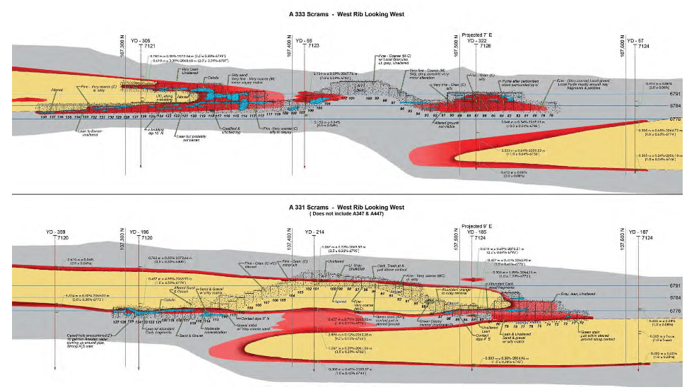
To Enlarge Section, Click (here)
After careful observations in the underground mine, along with detailed mapping and the construction of cross sections, the now accepted and useful exploration tool, the roll-front model of uranium ore deposition, was formulated and subsequently proven for use by the uranium exploration and mining industry.
In the Shirley Basin high-grade ore was mined underground from poorly consolidated sand and gravel deposits of the Lower Eocene Wind River Formation in
the early 1960s. These shallow sands, at depths of less than 115 meters (380 feet) were named the Sage Sand and the Turtle Sand. At the time of mineralization, groundwater transporting uranium in solution was generally moving from south to north, opposite of the current groundwater movement direction.
The sands and gravels were and remain saturated with groundwater, and the unstable ground and abundant water together created difficult underground mining conditions. The use of “square set” mining techniques was required in order to accomplish ore removal under these conditions. A geologic mapping program, carried out in the underground workings, accompanied by detailed drill hole logging and geologic cross section construction, revealed habits and relationships of the mineralization and associated alteration.
Mineralization and ore were found to lie along the periphery of tongues of “altered” ground. The greenish to rusty altered ground was usually recognizable in hand specimen and represented ‘leached’ ground through which mineralizing solutions had passed. The major tongue of alteration was found to be as much as 21 meters (70 feet) thick, tens of meters (hundreds of feet) across, and several kilometers long. The best ore occurred on what came to be called rolls or roll fronts (geochemical interfaces) at the terminal edges of altered ground, and additional ore was found to occur in “subsidiary” rolls on the upper
and lower surfaces of the altered ground.
The results of the mapping program provided data for improved planning for mining operations as well as more effective exploration and development drilling. Concerning the nature of uranium deposits in sandstone, the results of the studies in 1962 and 1963 at the Shirley Basin Mine were first, the concept of uranium concentrations at a geochemical interface and second, the development of the roll-front model of uranium deposits, as later defined and designed by by Rubin (1970) and Rackley (1975). This was a major breakthrough in knowledge and for understanding the nature of uranium deposits, particularly in sandstone deposits. The rollfront model was successfully applied to exploration and development drilling, to ore projections ahead of mine workings, and to reserve estimates in the Shirley Basin Mine. Subsequently, it has been used worldwide for understanding this type of deposit.
Managed & Built by I2M Consulting, LLC | © 2010-
