

TWDB reported in late 2022 that an update to the groundwater modeling for the district is available for comment. For background, in October 2019, the U.S. Geological Survey in cooperation with the Harris-Galveston Subsidence District and the Fort Bend Subsidence District began updating the groundwater flow model for the northern portion of the Gulf Coast Aquifer System.
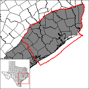
The model, known as the GULF-2023 model, is expected to be completed at the end of 2021. The TWDB and the Harris-Galveston Subsidence District have signed a letter of agreement that once the model and other deliverables satisfy the technical standards and procedural requirements of the TWDB GAM Program, the model, report, and source data will replace the Houston Area Groundwater Model (HAGM) as the GAM for the area.
In 2013, the US Geological Survey in cooperation with the Harris-Galveston Coastal Subsidence District, the Fort Bend Subsidence District, and the Lone Star Groundwater Conservation District have updated the model for the northern portion of the Gulf Coast Aquifer System (HAGM).
Hardwick indicated that as a part of the Texas Water Development Board Groundwater Modeling program, the U.S. Geological Survey has developed the Gulf Coast Land Subsidence and Groundwater-Flow model (the “GULF model”) and ensemble to simulate groundwater flow and land-surface subsidence in the northern part of the Gulf Coast aquifer system in Texas from predevelopment (1897) through 2018. Since the publication of a previous groundwater model for the greater Houston area in 2012, there have been changes to the distribution of groundwater withdrawals and advances in modeling tools. To reflect these changes and to simulate more recent conditions, the GULF model was developed in cooperation with the Harris-Galveston and Fort Bend Subsidence Districts to provide an updated Groundwater Availability Model.
In a generalized conceptual model of the Gulf Coast aquifer system, water enters the groundwater system in topographically high outcrops of the hydrogeologic units in the northwestern part of the aquifer system. Groundwater that does not discharge to streams flows to intermediate and deep zones of the aquifer system southeastward of the outcrop areas where it is discharged by wells and by upward leakage in topographically low areas near the coast. The uppermost parts of the aquifer system, which include outcrop areas, are under water-table (unconfined) conditions where the groundwater is not confined under pressure. As depth increases in the aquifer system and interbedded clay and silt layers accumulate, water-table conditions evolve into confined conditions where the groundwater is under pressure.
Groundwater flow and land-surface subsidence in the GULF model and ensemble were simulated by using MODFLOW 6 with the Skeletal Storage, Compaction, and Subsidence package. The model consists of six layers, one for each of the five hydrogeologic units in the northern part of the Gulf Coast aquifer system and a surficial top layer that includes part of each hydrogeologic unit. Transient groundwater flow was simulated during 1897–2018 by using a combination of multiyear, annual, and monthly stress periods. An initial steady-state stress period was configured to represent predevelopment mean annual inflows and outflows. The subsidence package used in the GULF model and ensemble uses a head-based subsidence formulation that simulates the delayed drainage response from clay and silt sediment to changes in groundwater levels.
The GULF model will replace the USGS Houston Area Groundwater Model (HAGM v1.1) as the official groundwater availability model for the Northern portion of the Gulf Coast Aquifer System and is therefore subject to public review. The TWDB will accept public comments on the GULF model. These comments are due to the TWDB by Monday, April 17th, 2023. Please email comments to either daryn.hardwick@twdb.texas.gov or gam@twdb.texas.gov .
The model files and report can be found at the TWDB website at https://www.twdb.texas.gov/groundwater/models/gam/glfc_n/glfc_n.asp.
Additionally, permanent links to these files can be found at:
Model Files: https://doi.org/10.5066/P9XM8A1P
Model Report: https://doi.org/10.3133/pp1877
Daryn Hardwick, Ph.D.
Managed & Built by I2M Consulting, LLC | © 2010-
