

Nofal, and three co-authors prepared this Preliminary Assessment Report under the National Instrument 43-101 Standards of Disclosure for Mineral Projects of the Canadian Institute of Mining and Metallurgy (CIM). It has been written to report on the conceptual engineering study conducted on the Westmoreland Uranium Project by GRD Minproc Limited (GRD Minproc) on behalf of Laramide Resources Limited (Laramide) as requested by Mr. Peter Mullens, VP Exploration and Project Development. The engineering study conducted, being preliminary in nature, was to ±30% accuracy.
The Westmoreland Uranium Project is located within a group of mineral tenements controlled by Laramide that extend for 200 km east-west and 150 km north-south, straddling the Queensland-Northern Territory border. Westmoreland is located in a region known as the Gulf Country, which includes the southern shores of the Gulf of Carpentaria and the country around the many rivers that flow into the Gulf. It is the largest tropical savannah region in Australia, with an area of 425 000 km2
The Westmoreland region was probably first prospected in the 1890s, after the discovery in 1887 of silver-lead deposits at Lawn Hill, 100 km south. Pitchblende was found in the Pandanus Creek area of the Northern Territory in 1955 by prospector R.T. Norris and mined in the late 1950s. In early November 1956, the Australian federal government Bureau of Mineral Resources (BMR) commenced an airborne scintillometer survey of the Westmoreland area. Information about the anomalies located by the BMR were provided to the holders of mineral tenements in the area as soon as they were available, together with a comment as to their relative value. [This type of federal government activity was also repeated by the U.S. Geological Survey's NURE Program beginning in the early 1970s]
While following up one of these anomalies in the second week of November 1956, a promising occurrence of torbernite was found in the Westmoreland Conglomerate, in the vicinity of Westmorland, by prospector A. Blackwell from Mount Isa Mines Limited (MIM). The deposit was given the name Redtree. Exploration by various companies through the next 15 years discovered numerous other deposits and prospects, and a significant resource of uranium was delineated.[American companies, such as Conoco, which was also active in the mid-1960s in the NW Queensland area already exploring for phosphate and which had substantial uranium holdings in the U.S., also investigated the subject areas but were closed out as the tenement claim-rush descended upon the areas of interest.]
Exploration continued in the Westmoreland region through the 1970s and 1980s. By 1990 CRA Ltd held a dominant interest in tenements in the region. An internal reorganization saw CRA absorbed into the Rio Tinto group, which by 1996 had published an inferred resource of 17.4 Mt at 0.12% U3O8 containing 20,900 t of U3O8 (Rheinberger et al, 1998).
Rio Tinto relinquished the EPMs in 2000 and subsequently Tackle Resources Pty Ltd filed applications over the areas previously held by Rio Tinto. Tackle was subsequently purchased by Laramide. It is noted that the current policy (2007) of the Queensland State Government does not allow the mining of Uranium Deposits. However, this policy is under review in light of the changing domestic and international political situations.
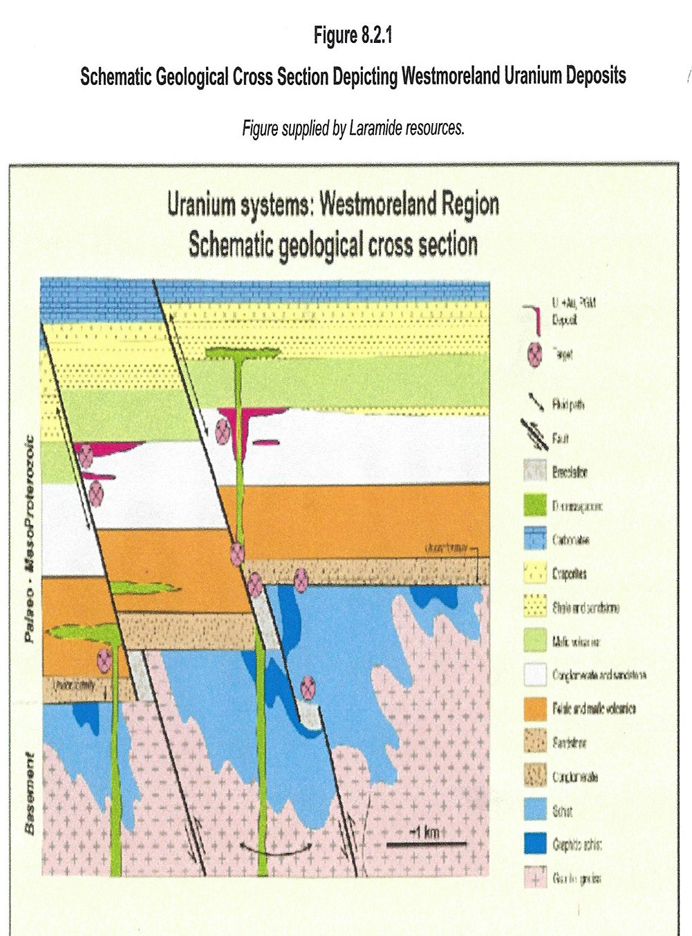
Laramide has obtained a commanding strategic position in the uranium exploration industry in Australia, by securing a series of contiguous mineral tenements that cover almost all of the known uranium deposits in the Westmoreland region. Previous exploration has identified a series of significant potentially economic deposits that require relatively modest investment to advance their status to an indicated resource. Westmoreland deposits occur within conglomerate, sandstone and mafic volcanic rocks. They have some features in common with both sandstone-hosted and vein types, as well as unconformity-related deposits. They are all associated with redox boundaries near the contact of different lithologies in various geological settings. Some geologists (e.g. Hochman and Ypma, 1984) consider the Westmoreland deposits to represent a special type of sandstone-hosted deposit (more).
SANDSTONE-HOSTED URANIUM DEPOSITS
Sandstone-hosted deposits are contained within fluvial or shallow marine sandstone. Host rocks are medium- to coarse grained, poorly sorted sandstones that generally contain pyrite and organic matter of plant origin. Primary mineralisation consists of pitchblende and coffinite, and weathering produces secondary minerals including carnotite and uranophane. Globally, sandstone-hosted deposits contain a large proportion of known uranium resources, although they are mostly of low to medium grade (0.05-0.4% U3O8). Individual deposits can contain up to 50 000 t U3O8, and cumulative tonnages within a province or basin may be several hundred thousand tonnes (Dahlkamp 1993).
UNCONFORMITY-RELATED URANIUM DEPOSITS
Unconformity-related deposits arise from geological changes occurring close to major unconformities. Below the unconformity, the rocks are usually faulted and brecciated. The overlying younger Proterozoic sandstones are usually undeformed. The ore minerals are generally uraninite and pitchblende. This type includes some of the largest and richest deposits of uranium known. The main deposits occur in Canada (the Athabasca Basin, Saskatchewan and Thelon Basin, Northwest Territories); and Australia (the Alligator Rivers region in the Pine Creek Geosyncline, NT and Rudall River area, WA). The deposits in the Athabasca Basin occur below, across and immediately above the unconformity, with the highest grade deposits situated above (e.g. Cigar Lake, averaging 9.1% U3O8, some zones over 50% U3O8) and across the unconformity (e.g. Key Lake).
Unconformity-related deposits constitute a major proportion (22%) of Australia's total uranium resources and more than 80% of Australia's total production since 1980 has been mined from two of these deposits: Ranger #1 and Nabarlek (now mined out). Other major deposits in the Alligator Rivers region are Ranger # 3, Jabiluka (North Ranger), Koongarra and Ranger 68. In the Alligator Rivers region, the known deposits are below the unconformity and are generally much lower grade than the Canadian deposits.
Pitchblende is the main uranium mineral and occurs on both the Westmoreland Conglomerate and the altered dykes. In the sandstones it occurs as grains between the sand particles, and also along fine fractures. Rare veins up to 1 cm thick have been reported. Some pitchblende has been dissolved by groundwater and re-distributed as sooty or colloform masses.
Gold has been noted as small grains up to 10 µm across either as inclusions in the pitchblende or in between the sand particles and in the dyke rocks. According to Schindlmayr and Beerbaum (1986), the origin of the uranium in the Westmoreland deposits is still open to interpretation. Introduction of uranium into the sedimentary system may have taken place either detritally, or by exhalative volcanogenic activity, or by hydrothermal remobilization from deep-seated sources. These geologists also postulate that heat flow at about 820 Ma generated and maintained hydrothermal convection cells in the permeable host rocks. Uranium introduced to circulating oxygenated formation waters by one or more of the above processes was precipitated against physicochemical barriers such as basic dykes or lavas, due to the abundant supply of divalent iron as a reducing agent. The Nicholson Granite is not the mineralising source as its pre-dates the Westmoreland Conglomerate.
Hochman and Ypma (1984) made thermoluminescence measurements on some 800 samples from the Westmoreland orebodies and surrounding host rocks up to 8 km away. They concluded that the Westmoreland Conglomerate has suffered major radiation damage attributable to at least 10 ppm uranium over 1 billion years, and that it had a high inherent uranium content that was remobilized in a convective cell system, possibly triggered by intrusion of dolerite dykes or by heat flow along rejuvenated structures.
Rheinberger et al (1998) also consider that the primary conduits for the uranium-bearing fluids are the major north-east structures such as the Redtree dyke zone. Migration of the uranium-bearing fluids away from the structures was controlled mainly by the porosity of the sediments. Uranium was precipitated adjacent to mafic rocks when oxidizing groundwater were reduced by reaction with Fe2+ in solution. Hematite also formed during the reactions. Chloride ions released by uraninite precipitation were used in chlorite formation. This explains the hematite-chlorite alteration. The flat-lying mineralization at Redtree formed immediately underneath the Seigal Volcanics and subsequent erosion of the basalt and weathering of the mineralisation has changed the primary assemblage. Uraninite has weathered to secondary uranium minerals and chlorite has weathered to a mixture of iron oxides and clay (Rheinberger et al, 1998).
Because the bulk of the known uranium resource is in sandstone, the deposits are collectively grouped here as of sandstone type. Subject to a change in state government policy in Queensland, Laramide could move quickly to a bankable feasibility study and, potentially, into production should this be warranted. Laramide has proposed to carry out the further drilling and evaluation at Westmoreland.
The objective is to complete sufficient work in 2007 to allow a pre-feasibility study to be completed by the end 2007, should permitting of a mine development seem likely and access to the site is obtained. Mining Associates is agreement with this plan. The budget is designed to support the drilling of 35,000 m of infill drilling to verify and improve the quality of previous drilling results. In addition, a further 5,000 m is allocated to expand the exploration of the area.
Managed & Built by I2M Consulting, LLC | © 2010-
